Meaning of 'Neighbourhood'

In its original sense, a neighbourhood comprised neighbours - people who lived near one another, who would know each other and share neighbourly relationships. According to the Wikipedia (6th May, 2007), “……traditionally, a neighbourhood is small enough that the neighbours are all able to know each other…. although this term may also be used across much larger distances in rural areas.
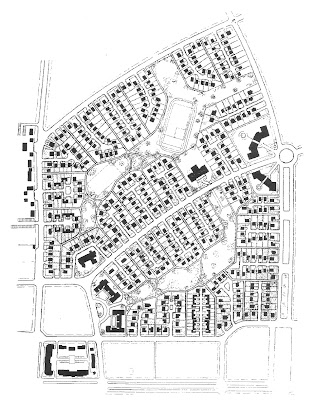
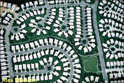
But in present use, a neighbourhood can also mean a geographically localised community, a residential district, located within a larger city, town or suburb. Although the residents of a given neighbourhood may be called neighbours, in practice, they may not know one another very well at all. This newer meaning of neighbourhood can be traced back to Clarence Perry and his idea of the ‘neighbourhood unit’.

Clarence Perry, a sociologist and member of the Regional Planning Association conceived “The Neighbourhood Unit – A Scheme of Arrangement for Family-Life Community”. Perry’s concept was part of an extended process of regional planning for the New York area done between 1922 and 1929. (Southworth, Eran). His aim was to find a fractional urban unit that would be self- sufficient yet related to the larger whole. He proposed planning principles for the comprehensive layout of residential areas:

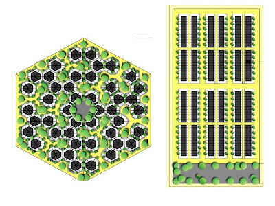
  • Population of about 3000 to 10000, being the size that would have its own elementary (primary) school of about 1000-1600 children.

  • The school, along with other communal facilities like hall, library and church would be centrally located.

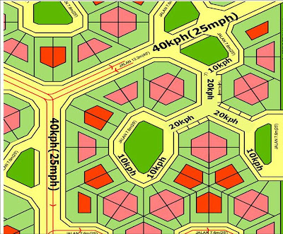
  • The neighbourhood would be ringed by arterial roads; the arterial road was to discourage through traffic into the residential neighbourhood, but also to give a distinct boundary to the neighbourhood.

  • The shopping area would be at the periphery of the neighbourhood, along the arterial road.

  • There should be a system of small parks and recreation areas to serve the children and youth. He suggested 10% of the total area to be a reasonably good provision.

  • The roads within the neighbourhood would be the small local roads in front of the houses and collector roads that joined the local roads to the arterial roads, the size of the roads being just big enough for the traffic load.


Perry wrote ‘Follow these prescriptions and you would have a neighbourhood unit that would stand out geographically as a distinct entity, and residents would feel a sense of belonging to that neighbourhood. When it has complete equipment from the vicinity needs of its families; when the public services are nicely adapted to population requirements and all its component parts are integrated by a comprehensive plan – then you have a neighbourhood community that is bound to be marked because the esteem in which it is held by its residents’.

Perry framed the concept of the neighbourhood unit after experiencing the benefits of a well planned suburban resident of Forest Hill Gardens on Long Island, a model of new suburban development. These suburbs, originally small and self contained helped to re-create a consciousness of something that had been lost in the rapid growth of cities – the sense of neighbourhood found in villages, and small towns. What Perry did was to make explicit, in a better defined structure, the life he had found rewarding.

Perry’s framework for the neighbourhood, brought within walking distance all the facilities needed daily by the home and school, and to keep outside this pedestrian area the heavy traffic arteries carrying people or goods that had no business in the neighbourhood. No playground, primary school or local shopping area should be more than a quarter of a mile (0.4km) from the houses they served. The population and geographical size was limited. Perry placed the population at 3000 to 10,000: large enough to supply a full variety of local services. The periphery would be physically defined by main roads or a green belt.

Perry had identified the fundamental social cell of the city as the neighbourhood.
(Lewis Mumford).

This idea of neighbourhood is not all wrong (later I shall return to it to see how it may help us design ‘block’ and ‘town neighbourhoods’ which might contain more than a thousand people). But it should not preclude us from using the word ‘neighbourhood’ in its original sense: a small community where people know each other. Many have explored the idea of the small community in environmental design but have used terms like ‘sub-neighbourhoods’ or ‘homezones’. Other relevant words are ‘semi-public’ or ‘semi-private’ areas.

A website based on the work of Christopher Alexander, author of Pattern Language (1977) says: ‘In our view, almost any part of the environment may be viewed as a neighborhood. A neighborhood can be very small (less than an acre), or quite large (hundreds ofacres). It can be a hospital, a business, a group of workshops, a place where people live and work. A neighborhood is any group of people and their activities, animals, buildings, plants, and public space. Neighborhoods of different sizes are usually nested inside one another’.
I will just use the word neighbourhood, and qualify it with prefixes like ‘courtyard’, ‘cul-de-sac’, ‘block’ or ‘town’; and, from here on, without parentheses.

Just as Perry asked how we should design the neighbourhood unit, we ask, how we should design small neighbourhoods.

Hierarchy of Needs

The Hierarchy of Needs is a theory in psychology that Abraham Maslow proposed in his 1943 paper ‘A Theory of Human Motivation’. His theory contends that as humans meet 'basic needs', they seek to satisfy successively 'higher needs' that occupy a set hierarchy.

Maslow's hierarchy of needs is often depicted as a pyramid consisting of five levels: the four lower levels are grouped together as deficiency needs associated with physiological needs, while the top level is termed growth needs associated with psychological needs. While deficiency needs must be met, growth needs are the need for personal growth. The basic concept is that the higher needs in this hierarchy only come into focus once all the needs that are lower down in the pyramid are mainly or entirely satisfied. Once an individual has moved past a level, those needs will no longer be prioritized. However, if a lower set of needs is continually unmet for an extended period of time, the individual will temporarily re-prioritize those needs - dropping down to that level until those lower needs are reasonably satisfied again. Innate growth forces constantly create upward movement in the hierarchy unless basic needs remain unmet indefinitely. (Cited from Wikipedia 7thMay, 2007)


Maslow's hierarchy of needs, represented as a pyramid with the more primitive needs at the bottom

From this perspective, a sense of neighbourhood can help meet an individual’s need for safety and belonging. But of these two categories it is the former which is more basic, which needs to be met first, before the latter, higher level needs can come into focus.

It makes sense therefore to discuss the design of neighbourhoods in the order of their prior importance, and I propose for general topics: - safety, comfort, congeniality, identity. I will also be bold enough to suggest that the physical design of neighbourhood can help individuals meet growth needs.

Protection from Crime

One aspect is safety from crime, and the concept of “Defensible Space” which evolved some 40 years ago when American architect Oscar Newman was witness to what happened at the newly constructed, 3,000-unit, public housing high-rise development at Pruitt Igoe. This was an infamous public housing scheme that was eventually demolished.

However, across the street from Pruitt-Igoe was an older, smaller, row-house complex occupied by an identical population, Carr Square Village. It remained fully occupied and trouble-free throughout the construction, occupancy, and decline of Pruitt-Igoe. With the social variables constant in the two developments, what, Newman asked himself, was the significance of the physical differences that had enabled one to survive while the other fell apart?


Pruitt Igoe - architectural illustrations versus actual photos

Newman believed that that design should propagate “natural surveillance” generating opportunities for people to see and be seen continuously. Knowing that they are, or could be, watched makes residents feel less anxious, leads them to use an area more and deters criminals by making them fear being identified and caught.
Second, people must not only watch but also be willing to intervene or report crime when it occurs. Newman proposed reducing anonymity and increasing territorial feelings by dividing larger spaces into zones of influence. This can be accomplished on a small scale by clustering a few apartments around a common entrance or a common elevator. On a larger scale individual yards or areas can be demarcated by having paths and recreational areas focus around a small set of apartment units or by having each building entry serve only a limited number of apartments.
Newman considered man as a territorial being, as a being that needs territory like he needs water, in order to be able to live a satisfactory life. He posited that man is not basically criminal – preferring social cohesiveness to anarchy, social harmony to tension. Providing surveillance over defensible spaces allows man to be in his natural state, surveying and defending his domain.
Newman and his followers tested these ideas by studying housing developments in cities across the country, from New York to San Francisco, and concluded that rates of crime, vandalism and turnover were lower in places that conformed to the principles of defensible space. In a variety of large and small cities, housing projects and urban neighborhoods have been redesigned in accord with defensible space principles. While the results have not been consistent, reductions in crime and fear and increases in a sense of community have been found in several places. The concept of Defensible Space enabled residents to take back control of their neighbourhoods and reduce crime. (Charles Mercer).

As for the Pruitt Igoe project, it was demolished by controlled explosion. Minoru Yamasaki would later design the World Trade Center. This was one very unlucky architect.


Pritt Igoe demolished

Oscar Newman’s idea of “Defensible Space” has been augmented by the work of psychologists in the area of CPTED, Crime Prevention Through Environmental Design.
CPTED strategies rely upon the ability to influence offender decisions that precede criminal acts. Research into criminal behaviour shows that criminals are more influenced by cues to the perceived risk of being caught than by cues to reward or ease of entry. Consistent with this research, CPTED based strategies emphasize enhancing the perceived risk of detection and apprehension.
Consistent with the widespread implementation of defensible space guidelines in the 1970s, most implementations of CPTED as of 2004 are based solely upon the theory that the proper design and effective use of the built environment can reduce crime, reduce the fear of crime, and improve the quality of life. Built environment implementations of CPTED seek to dissuade offenders from committing crimes by manipulating the built environment in which those crimes proceed from or occur. The three most common built environment strategies are natural surveillance, natural access control and natural territorial reinforcement. Natural surveillance and access control strategies limit the opportunity for crime. Territorial reinforcement promotes social control through a variety of measures.


Natural surveillance


Natural surveillance increases the threat of apprehension by taking steps to increase the perception that people can be seen. Natural surveillance occurs by designing the placement of physical features, activities and people in such a way as to maximize visibility and foster positive social interaction among legitimate users of private and public space. Potential offenders feel increased scrutiny and limitations on their escape routes. (Cite Wikipedia CPTED 7th May 2007)
looping road and the central green area are focal points with plentiful ‘eyes on the street’.

  • Windows are also placed overlooking the short stretches of connecting roads and footpaths and points of entry.

  • Use the shortest, least sight-limiting fencing

  • Natural surveillance measures can be complemented by organizational measures like, for example, closed-circuit television (CCTV) cameras.


From inside this house the residents can see the activities outside. In fact the courtyard becomes the focus of the neighbourhood, because all houses in the courtyard are facing it.

Natural access control


Natural access control limits the opportunity for crime by taking steps to clearly differentiate between public space and the localised neighbourhood.
The honeycomb cul-de-sac would typically have one vehicular entrance route and perhaps one or two footpaths. Placing clearly identifiable design cues at these entrances will further limit access or control flow, and improve natural access control.


Into the courtyard above is only one entrance with many windows placed to overlook it.

Natural territorial reinforcement


Territorial reinforcement promotes social control through increased definition of space and improved proprietary concern. An environment designed to clearly delineate private space does two things. First, it creates a sense of ownership. Owners have a vested interest and are more likely to challenge intruders or report them to the police. Second, the sense of owned space creates an environment where "strangers" or "intruders" stand out and are more easily identified.
Territorial reinforcement measures make the normal user feel safe and make the potential offender aware of a substantial risk of apprehension or scrutiny.


In this courtyard, the residents are invited by shared landscaping and sports facilities to claim as their own.

Maintenance


It also encourages the residents to maintain the common space, and this is also an important element in the expression of ownership of that common space. Deterioration indicates less control by the intended users of a site and indicate a greater tolerance of disorder. The 'Broken Windows Theory' is a valuable tool in understanding the importance of maintenance in deterring crime. Broken Windows theory proponents support a zero tolerance approach to property maintenance, observing that the presence of a broken window will entice vandals to break more windows in the vicinity. The sooner broken windows are fixed, the less likely it is that such vandalism will occur in the future.

Protection from Traffic

Another aspect of security is that of safety from traffic, and this has been an issue from the earliest days of the private car. In the US for instance, car ownership rocketed in the early 1900’s when prices became affordable, a good road system was developed, and new innovations that made driving easier and safer. The private car had a great impact on the social, economic and political structure of modern society. It brought new opportunities to individuals and families, and allowed for the development of new suburban communities away from the city center and public transport routes. Street design to cater for the private car became a key issue in planning and development, and a determining factor in shaping he pattern of the environment.
There was resistance against the growing influence of the motorcar. Clarence Stein, a planner wrote:

American cities were certainly not places of security in the twenties. The automobile was a disturbing menace to city life in the USA –long before it was in Europe….The flood of motors had already made the gridiron street pattern , which had formed the framework for urban real estate for over a century, as obsolete as a fortified town wall…..The checkerboard pattern made all the streets equally inviting to through traffic. Quiet and peaceful repose disappeared along with safety. Porches faced bedlams of motor throughways with blocked traffic, honking horns, noxious gases. Parked cars, hard grey roads and garages replaced gardens.
(Clarence Stein)


Clarence Stein and his colleague Henry Wright went on to design "a town for the motor age" in Radburn, New Jersey. They pioneered the concept of separating pedestrians from cars. The Radburn plan places the housing on long narrow cul-de-sacs for car access. Footpaths were placed at the opposite side of the houses providing pedestrian access to central green areas and communal facilities like schools. Thus, children could walk to school and play areas without crossing any street. Radburn introduced the largely residential "superblock" and had some of the earliest cul-de-sacs in the United States(Southworth and Eran).


The "town for the automobile age" did not take into account just how popular the automobile was going to be. Most of the Radburn homes are on small cul-de-sacs ending at a park; this design was intended to accommodate automobiles without requiring them. As latter 20th century economics and practice resulted in families with multiple cars, congestion arose on the cul-de-sacs where parking outside of one's own driveway was limited. (Cited from Wikipedia 7th May 2007).

Elsewhere in America, the pervasiveness of the private car unleashed forces that created highways and real estate developments into the open country that urban sprawl that typifies much of the country’s landscape today.

As soon as the motor car became common, the pedestrian scale of the railroad neighbourhoods disappeared, and with it, most of its individuality and charm. The suburb ceased to be a neighbourhood unit: it became a suffused low density mass. But the motorcar had done something more than destroy the pedestrian scale, it either doubled the number of cars needed per family, or it turned the suburban wife into a full time chauffeur. Cite Lewis Mumford,The City in History, 1961, pp 504-506.


The priority given to vehicles also posed problems of safety. As James Howard Kunstler puts it in The Geography of Nowhere: The Rise and Decline of America's Man-made Landscape: “The traffic engineer is not concerned about the pedestrians. His mission is to make sure that wheeled vehicles are happy. What he deems to be ultra-safe for drivers can be dangerous for pedestrians who share the street with cars. Anybody knows that a child of eight walking home from school at three o'clock in the afternoon uses a street differently than a forty-six-year-old carpet cleaner in a panel truck. After decades of preoccupation with the needs of the carpet cleaner, it's time to rethink streets and roads with the needs of that eight-year-old in mind.”


Shared Streets


Whilst the Radburn model separated cars from traffic, another model emerged in Europe in the 60’s. The model is one of integration, with an emphasis on the community and the residential user. Pedestrians, children at play, bicyclists, parked cars, and moving cars all share the same street space. Even though it seems the these uses conflict with one another, the physical design is such that drivers are placed in an inferior position. Such conditions are naturally much safer than the conventional street design. By redesigning the physical aspects of the streets, the social and physical public domain of the pedestrian is reclaimed.


The philosophical roots of the shared streets concept can be found in a report, Traffic in Towns, in 1963 by an architect and traffic engineer, Colin Buchanan and his team. They were able to see the conflict between providing for easy traffic flow and the maintenance of the residential and architectural fabric of the street. They suggested segregating traffic and pedestrians completely in certain environmental areas, allow mixing of vehicles and pedestrians in others, The concepts of ‘traffic intergration’ and ‘traffic calming’ were not initially well received in Britain , but they proved to have more impact in the Netherlands, where it inspired Niek De Boer, professor of urban planning at Delft University, to design streets so that motorists would feel as if they were driving in a ‘garden’ setting, forcing drivers to consider other road users. De Boer named the street “woonerf’ or ‘residential yard’. The Delft Municipality decided to experiment with this idea and its success spread throughout the Netherlands in the form of design standards and traffic regulations.


Shared streets integrate pedestrian activity with vehicular movement on one shared surface, but the pedestrian and bicyclist have priority over the car. These streets are often at the same grade as curbs and sidewalks. Cars are limited by law to a speed that does not disrupt other uses of the streets (usually defined as walking speed). To make this lower speed natural, the street is normally set up so that a car cannot drive in a straight line for significant distances, for example by placing planters at the edge of the street, alternating the side of the street the parking is on, or curving the street itself. Other traffic calming measures are also used. However, early methods of traffic calming such as speed humps are now avoided in favor of methods which make slower speeds more natural to drivers, rather than an imposition.

Even though many people were afraid that the mixing of vehicles and pedestrians and play area on one surface could be dangerous, studies that have been done in the Germany, Denmark, Japan and Israel show that there are 20% fewer accidents in shared streets and over 50% fewer severe accidents compared with standard residential streets.

The most prevalent traffic accidents on standard residential streets are children-related accidents. According to a study in England, half of all road accidents with children under five occur within 100 meters of their homes. The same survey showed that very few such accidents occur on streets with restrictive devices and shared streets or cul-de-sac designs. The safety results in Europe and Asia appear to be similar.

The Honeycomb design can incorporate the design features of the shared street. However, even without traffic legislation to impose maximum speed in these areas, and the adoption of a single surface for pedestrians and vehicles, some of the effect of the shared streets in terms of safety and security can be achieved.

A car entering a Honeycomb development would have to slow down at the entry junction but would not have much opportunity to regain speed – the longest straight stretch of distribution road being less than 150 meters (500’). After slowing down to enter a cul-de-sac, the longest straight stretch of road is only 25 meters (80’). House entrances are off a looping road where cars have to slow down further.

We would target the following vehicle speeds by placing further traffic calming measures, notably introduction of rough strips of pavement across the roads at strategic locations:

• Distribution road: maximum 40 kph
• Straight stretch of connecting roads into cul-de-sacs: maximum 20 kph
• Looping road in courtyard: maximum 10 kph

Walking speed is about 6kph.


Protection from Climate

Safety concerns met, a need that then comes into focus is comfort. In Malaysia, as in many tropical countries, and in temperate countries with hot summers, outdoor thermal comfort is an important consideration.

Many cities suffer from overheating, whereby the ambient air temperature in suburban and downtown urban areas can be 2 to 3 degrees Celsius hotter than in rural areas. This is termed the urban heat island effect and is caused by fewer plants and trees and the greater absorption of solar radiation by more buildings and roads. These temperature increases, although seemingly small from an engineering viewpoint, have profound effects on human comfort.


Outdoor Heat Stress


Meteorological data collected between 1975 and 1995 from the Subang weather station, Kuala Lumpur, Malaysia reveals that the average outdoor temperature in Kuala Lumpur has increased by 1.20C during this 21 year period. As shown Kuala Lumpur is getting hotter by 0.60C per decade.


This finding supports anecdotal subjective evidence from long term residents of Kuala Lumpur who claim city living is becoming more and more uncomfortable compared to the rural areas. This previously unreported data was part of a larger study to construct a Malaysian weather year, termed a Test Reference Year (Reimann et al 2000).An objective measure of heat stress imposed by the outdoor Malaysian environment during different periods of the year has been calculated from the Test Reference Year in a novel Thermal Discomfort index.


One unit of thermal discomfort is defined here as the heat stress suffered by a person wearing light tropical clothing whilst resting outdoors for one hour in the shade with no wind whilst the average ambient temperature is 10C above the upper thermal comfort level (estimated to be 280C for the Malaysian humid tropics, Davis et al 2000). For example, a person under these conditions when the average ambient temperature between 1pm and 2 pm is 330C suffers, by definition, 5 units of thermal discomfort. These units per hour, summed over 24 hours, provide a quantitative measure of human heat stress for that particular day.

The results reveal that the population of Malaysia suffers outdoor heat stress throughout the year; there is no cool season. Whilst Malaysia, being close to the equator, is hot every day of the year, this index reveals for the first time the true but rather hidden seasonality as felt by humans. Two heat-waves, imposing 40 units of thermal discomfort per day, occur regularly in March and May whilst the 4 months from September to December are much more pleasant, imposing only 15 units of thermal discomfort per day.

Indoor Heat Stress

The situation indoors is not much better. Study at UPM has shown that nearly all of the modern concrete houses built over the last 50 years in Malaysia grossly overheat (Davis et al 1995, 1997, 2002, 2003). In one example a single story concrete terrace house during a heat-wave is way above the upper thermal comfort level every minute of the night and day.


However, the outdoor environment is perfectly comfortable for 14 hours per day. Experiments such as this during different times of the year, using a miniature temperature data-logging technique (Davis et al, 1995), has established that all 2 million modern concrete houses cause two to three times more thermal discomfort (heat stress) than the outdoor environment. The general though rather sad conclusion is that the Malaysian urban population would be far more thermally comfortable if they abandoned their houses and lived under trees. This absurd situation has provided the motivation to design sustainable thermally comfortable houses which avoid or minimize the high electricity cost of air-conditioning.

Thermally Comfortable Neighbourhoods

The Honeycomb Thermal Comfort housing concept applies two approaches: firstly, the houses themselves are designed to minimize heat gain by shading, insulation and the thermal capacity of the building fabric is employed as a heat sink by cooling it at night. Secondly, applying the Honeycomb layout concept permits a very lush urban landscape in the gardens and neighbourhood parks to mitigate the heat-island effect by shading the hard external surfaces.

Our research show that this alternative design approach uses land efficiently, that there is potential to reduce infrastructure cost, and that the consumer reaction to this new concept is favourable.


The first step in combating the heat-island effect is to reduce the heat gain of the buildings themselves. This reduces the heat load of buildings and makes them more comfortable for the occupants and reduces the use of energy for air-conditioning. Preventing the thermal mass of buildings that make up the concrete jungle from heating up during the daytime is not only an effective strategy for passively achieving indoor thermal comfort in Malaysia, but it also lowers the radiation from the buildings to the outdoor environment. Happily, to the extent that this radiation contributes to the heat island effect, thermal comfort technology may also have a positive effect on external temperature.

The urban roads in Malaysia are the other major contributor to the heat island effect. The roads are surfaced in black bitumen and fully exposed to direct sunlight which optimizes the absorption of solar radiation, grossly overheats the roads and the subsurface layer of hardcore. Roads also comprise almost half the of the land area of Malaysian terrace house townships. Urban roads are therefore an enormous heat sink in Malaysia and need to be shaded from direct sunlight by canopy trees. This is not always possible in the grid land subdivision typified by terrace housing. Mainly small are trees grown along streets since their roots will be blocked by services and drains, and these trees offer virtually no shade to roads. New Malaysian housing estates are becoming increasingly like desert townships, too hot and devoid of nature.

In the Honeycomb layout, the green area in the courtyards is for big trees to be grown, undisturbed by drains or sewage pipes, providing almost complete shade to the courtyard roads as they mature to 12 to 18 meters in height. to mitigate the heat-island effect by shading the hard external surfaces (figure 10). Honeycomb housing layouts can permit a very lush urban landscape in the gardens and neighbourhood parks. The winding roads can also be tree lined to provide shade. The aim is to recreate a rainforest type canopy over the township as the trees mature over a 5 to 10 year period to reduce the heat island effect.


From our Honeycomb mathematical model, we have estimated the potential tree canopy area of the above honeycomb township to be 46%, compared to only 15% for a row housing, typical of a Malaysian terrace house township. Modifying the indoor climate is clearly achievable with existing technology, correctly applied for any particular climate and culture.

It is already well known that cul-de-sac layouts yield more saleable land compared to rectilinear grid layouts (Southworth and Joseph 2001), however cul-de-sac arrangements of ‘single-family’ detached houses cannot match the densities achieved by terrace housing. The Honeycomb layout is a cul-de-sac arrangement that allows for linked ‘multi-family’ units and can match (or even exceed) the densities achieved by terrace housing.

We have demonstrated earlier that honeycomb housing produces here greatly increased land use efficiencies. These advantages are summarized in the mathematical table comparing the terrace housing against quadruplex/sextuplex honeycomb housing in the section on tessellation maths. The density between the two is the same but the amount of road for the Honeycomb layout is only 33% against 47% for the terrace layout. Consequently, the average size of each lot is 30% larger, leaving more area for gardens. There will thus be more soft green surfaces and less hard surfaces with the ability to absorb heat.

Provide an Arena for Social Contact

When pre-requisite conditions like safety and comfort have been met, we can look at the function of the space just outside the home as a social space. Can environmental design render this space more conducive to social use? In his book “Life Between Buildings”, first published in 1971, Jan Gehl saw outdoor activities as an important precursor of contact and social relationships. He argued that there were three types of outdoor activities: necessary activities, ‘optional’ activities and social activities. The frequency of the necessary activities, like going to work, shop and other activities that people must do in everyday life, did not vary whether the contact at a modest level

• starting point for contact at higher levels
• maintaining already established contact
• a source of information about the social world outside
• an offer of stimulating experience
The effect of the quality of the environment on the level of outdoor activity in it is clearly shown in a study which compared the frequency of outdoor activities and contacts between friends in three parallel streets in San Francisco. Registration of frequency of occurrence of outdoor activities (dots) and contacts between friends and acquaintances (lines) in three parallel streets in San Fransisco.

Top: Street with light traffic
Center: Street with moderate traffic.
Bottom: Street with heavy traffic. Almost no outdoor activities and few friendships and acquaintances among the residents.


Factors that encourage outdoor activities

So what are the factors that planners need to consider? For the small neighbourhood they include designing for the human scale, concentrating focus rather than diffuse dispersal, integrating different functions and characteristics rather than segregation, and soft edges.
Human Scale

Anthropologist E. T. Hall wrote "The Hidden Dimension" which developed and popularized the concepts of personal space - the distance between men in the conduct of daily transactions, the organization of space in his houses and buildings, and ultimately the layout of his towns."

Hall defined and measured four interpersonal "zones":

  • intimate (0 to 18 inches)

  • personal (18 inches to 4 feet)

  • social (4 feet to 12 feet)

  • public (12 feet and beyond)


In "The Hidden Dimension" he famously observed that the precise distance we feel 'comfortable' with other people being near us is culturally determined: Saudis, Norwegians, Milanese and Japanese will have differing notions of 'close'.

In ‘The Hidden Dimension’ Edward Hall defines distances in terms of human communication within European and American culture:
  • Intimate distance of below 18 inches (<45cm)>
  • Personal distance of 18 inches to 4 feet (45cm to 1.2m) is the conversation distance between close friends and family. This is the distance between people around a dining table.

  • Social distance, 4feet to 12 feet (1.2 to 3.6m), is the distance for ordinary conversation between friends, co-workers, neighbours, etc.

  • Public distance of more than 12 feet (3.6m), is defined as the distance used in more formal situations, around public figures or in teaching situations with one way communication or when someone wants to hear but does not wish to get involved.

This perspective gives a human dimension to distances and scale. In old cities narrow streets and squares, the buildings and the people in it are experienced at close range and considerable intensity and are perceived as intimate, warm and personal. Conversely many modern projects with large spaces, tall buildings and wide streets are felt to be cold and impersonal.

There must also be time to see and process visual information. Human sensory perception are mainly designed for walking or running speed (3 to 9kph). As the speed is increased, the possibility of discerning details and processing social information drops sharply. On the highway, signs and billboards have to be huge and bold to be seen. Buildings are comparatively large and details are few since they these cannot be seen anyway. Faces and facial expressions of people are too small to be perceived at all.
Apart from scale and speed , other factors that inhibit or encourage contact are sightlines– in terms of barriers or walls, multiple levels or orientation.


IsolationContact
WallsNo walls
FarNear
Fastslow
Multi-levelOne level
Facing towardsFacing away


Much of town-planning is concerned with the sub-division of land into different functions and then creating circulation routes connecting them. The functional city comprised mono-functional zones. Work separated from home, separated from recreation; the rich separated, separated from the middle class, separated from the poor. University towns, administrative capitals, retirement villages perhaps brought some benefits of efficiency but pay the price of being isolated from other groups in society. By contrast, in traditional towns, rich and poor, merchants and craftsmen, young and old had to live and work side by side. In ‘The Death and Life of Great American Cities’ Jane Jacobs pp153- 177, is a cogent argument of how diversity increases the range of hours streets, shops and city amenities are frequented. By this convenience, liveliness and variety of choice are increased. In an offices only district, the streets are busy only during office hours but deserted otherwise. In areas where residential and workplaces are mixed, the streets are occupied throughout longer hours to the benefit of businesses.

Another aspect of integration is that between vehicular traffic and pedestrians. He argues that separation of traffic and pedestrians like in the Radburn model diffuses outdoor activity. It becomes duller to drive, duller to walk, duller to live along because a significant number of people in transit are now segregated away. He advocates the Woonerf as a better solution: where vehicular traffic moves at pedestrian speed, the arguments for separating playing, walking and the areas for traffic lose their validity.

Concentration

Parallel to the development of functionalistic town-planning is the spread of low-density, single family homes in the suburbs made possible by the increased use of cars. In these areas desirable conditions have been created for private use by the family, but residential areas have a diffuse structure and uncertain boundaries, It is not clear where the individual belongs, where the neighbourhood ends. The design of the residential streets rarely takes into account where and how communal activities can take place. The shopping mall becomes the main place for contacts. Conversely designs of courtyard housing can provide a focus for small community activities. With this architectural form, activities that originate from the area in front of the houses at the house entrances can grow from the edge to the middle.


People are attracted to other people

A lively place attracts more to come, An illustration of this was found in studying the pattern of children’s play in areas of high and low-density housing in Denmark. In the terrace house areas, where the ‘density’ of children was twice the density of detached houses, four times the number of play activity was found. On the other hand, a dull, deserted place remains deserted.

Children’s playground equipment provides a good excuse for children to come out. A child playing by himself can easily attract other children. They socialize most easily. Watching children play is a pleasurable entertainment for most adults, and in this way, invite parents to come out too.

Soft Edges

A study of the frequency and duration of all types of activity on twelve residential streets in Waterloo and Kitchener, Ontario showed that although ‘come and go’activities account for more than 50% of the total number of activities happening on 12 streets surveyed, stationary activities are the ones that bring life to the streets. Because of their duration, they account for an impressive 90% of all time spent on the streets.


In a study of two parallel streets in Copenhagen, a hard edge street, suitable only for brief comings and goings, was compared to a soft-edge street - where it was easier to go in and out where there were suitable areas for stationary activities and which provided something to do in front of the house – the soft-edge street had three times more activities in the course of a normal day compared to the hard-edge street.


These houses were moderately close to together and have semi-private porches facing the street. “The study of row-house areas with semi-private front yards in Canada …and Scandinavia emphasize that even very small outdoor areas placed directly in front of houses can have a far greater and substantially more faceted use than larger recreational areas that are more difficult to reach. This does not mean that that areas for sports, green lawns and city parks are in any way superfluous, but it means that in all cases there should be areas and resources set aside to provide “immediate” recreational areas. The few well-designed square feet next to a dwelling will most often be more useful and more used than the larger areas farther away.”

Encourage a Sense of Belonging

In his book, Jan Gehl also mentions a Danish cooperative project in Tinggarden, consisting of 80 rental units built in 1978. Here planning was a joint venture of future residents and the architects and illustrates a clear attitude towards a desired social structure.

The physical structure of the building complex reflects and supports the desired social structure. There is a hierarchy of communal spaces: the family has a living room; residences are organized around an outdoor square and an indoor communal house; finally the whole complex is built around a public main street in which a large communal centre is also located. Visually, the social structure is expressed by placing the residences around group squares or streets. Functionally, the social structure is supported by establishing communal spaces at various levels in the hierarchy structure.

The hierarchical division – dwelling, dwelling group, housing complex, city – is motivated by the wish to strengthen the community and the democratic process in the housing development.

In describing Tinggarden, Gehl alludes to another possible source of life between buildings - not activity and casual contact – but the grouping of dwellings to correspond to possible social groupings.

The 1970’s was the decade of the ‘Human Ape’, perhaps at the infancy of evolutionary psychology, and social scientists were starting to relate human behaviour to animal behaviour. Charles Mercer in ‘Life in Cities’ speculated about man as a territorial being, as a being that needs territory like he needs water, in order to be able to live a satisfactory life; that man is not basically criminal – preferring social cohesiveness to anarchy, social harmony to tension. Providing surveillance over defensible spaces allows man to be in his natural state, surveying and defending his domain.

I think there is a simpler alternative to the model of man as a ‘territorial animal’, and that is of him as a social being.

Newman observed that landings shared by only two families were well maintained, whereas corridors shared by 20 families, and lobbies, elevators, and stairs shared by 150 families were disasters - they evoked no feelings of identity or control. Such anonymous public spaces made it impossible for residents to develop an accord on what was acceptable behavior in these areas, impossible for them to feel or exert proprietary feelings, impossible to tell resident from intruder. Newman concluded that residents maintained, controlled, and identified with those areas that were clearly demarcated as their own

But then another explanation is that where households were arranged in small groups, they cooperated better in looking after the space they shared. . People interact more easily in small groups rather than big. The importance of size in group behaviour is a very much investigated topic in social psychology.

Conversation groups

How many people can hold a casual conversation? Observation has shown that casual conversation groups are limited to 4 persons. Conversation groups never contain more than one speaker at a time. When there is more, no one can keep track of the conversations and the group breaks up or one speaker tries to rule.
There are obvious physical limitations. Speech becomes less clear when the distance between speaker and hearer increases. A nose-to- nose distance of 1.7m was found to be the upper limit for comfortable conversation; this would yield a maximum conversation group size of five individuals with a shoulder-to- shoulder spacing of 0.5m between adjacent individuals standing around the circumference of a circle. Studies suggest that, as the circle of people taking part in a conversation expands, the distances between speaker and listeners across the circle rapidly become too large for conversations to be heard. Robin Dunbar studied conversational cliques that varied in size from 2-10 individuals. They found that the average number of people directly involved in a conversation (as speaker or attentive listener) is about 3.4 (one speaker plus 2.4 listeners) and that groups tended to partition into new conversational cliques at multiples of about four individuals.
When larger numbers of people want to talk together, a more formal format has to be adopted, where someone like a chairman can control the interaction. Cite
Dunbar, R. I. M. (1993). Coevolution of neocortical size, group size and language in humans. Behavioral and Brain Sciences 16 (4): 681-735.

Sympathy groups

‘List the names of everyone whose death tomorrow they would find devastating’. This question has been put to respondents around the world and across cultures, but the results have been impressively consistent. The average number is 11 to 12
Why not larger? It has been postulated that caring about people takes effort. At some point between 10 and 15 appears to be a threshold beyond which is emotional overload. Cite Malcolm Gladwell ‘Tipping Point’

Group Theory

A social group is a collection of two or more people who interact frequently with one another, share a sense of belonging, and have a feeling of interdependence.
In a group of two there is only one relationship. In a group 4, there are 10 separate relationships – your relationship with 4 others plus the other 6 two way relationships.
In a group of 20, there are 190 relationships. There is a logarithmic relationship between group size and the number of one-to-one relationships between the members of the group. This has been used to explain why there seems to be an upper limit to the size of social groups across time and environment. In his book “Grooming, Gossip and Language”, Robin Dunbar discusses the upper limit of group sizes in Neolithic villages in Mesopotamia, the Hutterites - a fundamentalist group who live and farm communally in South Dakota and Manitoba, even academic communities appear to abide by this rule. It was found that research specialities in the sciences tend to consist of up to 200 individuals! In addition, it turns out that most organised (i.e. professional) armies have a basic unit of about 150 men.
Thus, neighbours who know and interact each other can be described as a social group. However, a group of neighbours who live on the same street, who happen to be in the same place at the same time but share little else would be described as an aggregate, a mere collection of people.

The neighbourhood in the sense that Perry introduced, with a population of 3000 to 10,000 people is to large to be a social group. The sense of neighbourhood that is talked about is more a sense of identification with the distinguishing features of a place and not based on the sense of belonging to a social group.

Provide Opportunity for Growth

It may perhaps appear as claiming too much that architectural design can help people meet higher level needs than lie at the top of Maslow’s pyramid: to help satisfy the human need for growth and self-actualization. Yet for pre-school children, the immediate outside environment can appear to be a new world to be discovered. For the old, it is a world that they can easily be isolated from. For most working adults, with our cars and life outside the home, we often place little importance on the place and people in our immediate neighbourhood, but not so for the least mobile sections of our society - the small children, the old and the disabled.


Malaysia's most famous cartoonist is Lat who tells the story of a young boy growing up in the countryside 40 years ago. This is sweet nostalgia for most Malaysians of my generation. But nowadays our young children do not have the same chance to explore their environment in the same carefree way.


Play areas


Play is an important arena for learning for the child; growing up can be seen as a process, where the child becomes more and more independent of the parent, exploring first the spaces around the mother and progressing to other rooms in the house and then the front yard. The opportunity for exploring new environment is best presented in small discreet steps so that children can explore them at their own pace.

The problem with the typical Malaysian situation is that the process of exploring new territory independent of the parent stops at the front gate, beyond which parents do not considered it safe. When the child is finally old enough to go out unaccompanied by an adult it is too big a transition and the child feels disadvantaged compared to the child that is able to explore bit by bit the neighbourhood around the home.

This suggests that the spaces outside the home should be made conducive to the growing up process. They should be safe for smaller children with ample play and civic amenities. Play areas with football fields some minutes away from the home do not serve the needs of preschoolers and young primary school children.

In the Honeycomb courtyards, in Honeycomb flats with their lobbies and 'Kotapuri', we aim to provide places just outside the home, relatively safe from strangers and traffic, where small children can play under the watchful eyes of their parents and neighbours.